![](/images/other/stat-length.png)
![Tour Wandern Le Mayet-de-Montagne - Saint Clément - Photo](https://media.geolcdn.com/t/1900/400/ext.pjpeg?maxdim=2&url=https%3A%2F%2Fservices.sitytrail.com%2FGeolivesWS%2FDownloadMedia.ashx%3FTrailID%3D103644%26Media%3D6073_3.jpg)
Saint Clément
tracegps
Benutzer
![Länge](/images/other/stat-length.png)
Länge
15,9 km
![Maximale Höhe](https://static1.geolcdn.com/siteimages/upload/files/1508320355ic_sort_altitude_max_24dp.png)
Maximale Höhe
760 m
![Positive Höhendifferenz](https://static1.geolcdn.com/siteimages/upload/files/1508320355ic_sort_den_pos_24dp.png)
Positive Höhendifferenz
536 m
![Km-Effort](/images/other/stat-length.png)
Km-Effort
23 km
![Min. Höhe](https://static1.geolcdn.com/siteimages/upload/files/1508320355ic_sort_altitude_min_24dp.png)
Min. Höhe
453 m
![Negative Höhendifferenz](https://static1.geolcdn.com/siteimages/upload/files/1508320355ic_sort_den_neg_24dp.png)
Negative Höhendifferenz
538 m
![Boucle](https://static1.geolcdn.com/siteimages/upload/files/16400158638029165_repeat_loop_refresh_sync_direction_icon.png)
Boucle
Ja
Erstellungsdatum :
2014-12-10 00:00:00.0
Letzte Änderung :
2014-12-10 00:00:00.0
![Wandern](https://static1.geolcdn.com/sitytour/trail-icons/101.png)
3h30
Schwierigkeit : Schwierig
![Scannen Sie diesen QR-Code, um die Tour in der SityTrail-Anwendung zu öffnen](https://capi.geolives.com/qq0zvz2zws4bq2lad0pu/sitytour/trails/103644/qr.png?size=200)
Kostenlosegpshiking-Anwendung
Über SityTrail
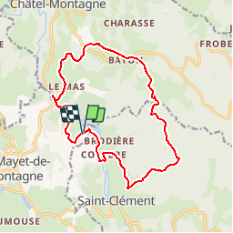
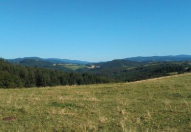
Tour Wandern von 15,9 km verfügbar auf Auvergne-Rhone-Alpen, Allier, Le Mayet-de-Montagne. Diese Tour wird von tracegps vorgeschlagen.
Beschreibung
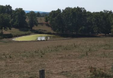
Départ du plan d'eau de Saint Clément. Attention la descente depuis la croix de Mondolin est piégeuse. Passage devant le centre de l'Europe des 12, un vieux souvenir!!! Au plan d'eau, diverses activités suivre le lien Plan d'Eau de St Clément.
Ort
Land:
France
Region :
Auvergne-Rhone-Alpen
Abteilung/Provinz :
Allier
Kommune :
Le Mayet-de-Montagne
Standort:
Unknown
Gehen Sie:(Dec)
Gehen Sie:(UTM)
553532 ; 5103077 (31T) N.
Kommentare
Touren in der Umgebung
![Tour Laufen Châtel-Montagne - jour 7 CAP Jeanot - Photo](https://media.geolcdn.com/t/375/260/8a698184-4193-4775-82fc-8cbe0040237c.jpg&format=jpg&maxdim=2)
![Laufen Laufen](https://static1.geolcdn.com/sitytour/trail-icons/103.png)
jour 7 CAP Jeanot
Laufen
Sehr leicht
Châtel-Montagne,
Auvergne-Rhone-Alpen,
Allier,
France
![](/images/other/stat-length.png)
33 km | 43 km-effort
4h 29min
![](https://static1.geolcdn.com/siteimages/upload/files/16400158638029165_repeat_loop_refresh_sync_direction_icon.png)
Nein
![Tour Wandern Châtel-Montagne - Le Puy du Roc - Châtel-Montagne - Photo](https://media.geolcdn.com/t/375/260/ext.jpg?maxdim=2&url=https%3A%2F%2Fservices.sitytrail.com%2FGeolivesWS%2FDownloadMedia.ashx%3FTrailID%3D173073%26Media%3D14605_6.jpg)
![Wandern Wandern](https://static1.geolcdn.com/sitytour/trail-icons/101.png)
Le Puy du Roc - Châtel-Montagne
Wandern
Medium
Châtel-Montagne,
Auvergne-Rhone-Alpen,
Allier,
France
![](/images/other/stat-length.png)
10,2 km | 15,3 km-effort
3h 0min
![](https://static1.geolcdn.com/siteimages/upload/files/16400158638029165_repeat_loop_refresh_sync_direction_icon.png)
Ja
![Tour Hybrid-Bike Châtel-Montagne - jour 7 - Photo](https://media.geolcdn.com/t/375/260/e89c6336-8612-483e-aed3-1c25fc42c2f5.jpg&format=jpg&maxdim=2)
![Hybrid-Bike Hybrid-Bike](https://static1.geolcdn.com/sitytour/trail-icons/203.png)
jour 7
Hybrid-Bike
Sehr leicht
Châtel-Montagne,
Auvergne-Rhone-Alpen,
Allier,
France
![](/images/other/stat-length.png)
27 km | 32 km-effort
2h 6min
![](https://static1.geolcdn.com/siteimages/upload/files/16400158638029165_repeat_loop_refresh_sync_direction_icon.png)
Nein
![Tour Wandern Châtel-Montagne - Balade autour du Mont Aigu - Le Moulin Chatel - Photo](https://media.geolcdn.com/t/375/260/ext.jpg?maxdim=2&url=https%3A%2F%2Fservices.sitytrail.com%2FGeolivesWS%2FDownloadMedia.ashx%3FTrailID%3D191451%26Media%3D15040_2.jpg)
![Wandern Wandern](https://static1.geolcdn.com/sitytour/trail-icons/101.png)
Balade autour du Mont Aigu - Le Moulin Chatel
Wandern
Medium
Châtel-Montagne,
Auvergne-Rhone-Alpen,
Allier,
France
![](/images/other/stat-length.png)
10,4 km | 14,1 km-effort
2h 30min
![](https://static1.geolcdn.com/siteimages/upload/files/16400158638029165_repeat_loop_refresh_sync_direction_icon.png)
Ja
![Tour Wandern Le Mayet-de-Montagne - Le Grand Roc - Le Mallot - Photo](https://media.geolcdn.com/t/375/260/ext.jpg?maxdim=2&url=https%3A%2F%2Fservices.sitytrail.com%2FGeolivesWS%2FDownloadMedia.ashx%3FTrailID%3D173257%26Media%3D14872_1.jpg)
![Wandern Wandern](https://static1.geolcdn.com/sitytour/trail-icons/101.png)
Le Grand Roc - Le Mallot
Wandern
Medium
Le Mayet-de-Montagne,
Auvergne-Rhone-Alpen,
Allier,
France
![](/images/other/stat-length.png)
10,4 km | 15,2 km-effort
2h 45min
![](https://static1.geolcdn.com/siteimages/upload/files/16400158638029165_repeat_loop_refresh_sync_direction_icon.png)
Ja
![Tour Pferd Saint-Clément - 2024-06-16_20h48m09_st-clement-03250 - Photo](https://media.geolcdn.com/t/375/260/ext.jpg?maxdim=2&url=https%3A%2F%2Fstatic1.geolcdn.com%2Fsiteimages%2Fupload%2Ffiles%2F1524743154cheval.jpg)
![Pferd Pferd](https://static1.geolcdn.com/sitytour/trail-icons/300.png)
2024-06-16_20h48m09_st-clement-03250
Pferd
Medium
Saint-Clément,
Auvergne-Rhone-Alpen,
Allier,
France
![](/images/other/stat-length.png)
30 km | 42 km-effort
Unbekannt
![](https://static1.geolcdn.com/siteimages/upload/files/16400158638029165_repeat_loop_refresh_sync_direction_icon.png)
Ja
![Tour Pferd Saint-Clément - 2024-06-16_20h47m36_Chatel_montagne (1) - Photo](https://media.geolcdn.com/t/375/260/ext.jpg?maxdim=2&url=https%3A%2F%2Fstatic1.geolcdn.com%2Fsiteimages%2Fupload%2Ffiles%2F1524743154cheval.jpg)
![Pferd Pferd](https://static1.geolcdn.com/sitytour/trail-icons/300.png)
2024-06-16_20h47m36_Chatel_montagne (1)
Pferd
Medium
Saint-Clément,
Auvergne-Rhone-Alpen,
Allier,
France
![](/images/other/stat-length.png)
25 km | 35 km-effort
Unbekannt
![](https://static1.geolcdn.com/siteimages/upload/files/16400158638029165_repeat_loop_refresh_sync_direction_icon.png)
Ja
![Tour Reiten Le Mayet-de-Montagne - saint clement 03250 30 kms - Photo](https://media.geolcdn.com/t/375/260/ext.jpg?maxdim=2&url=https%3A%2F%2Fstatic1.geolcdn.com%2Fsiteimages%2Fupload%2Ffiles%2F1524743154cheval.jpg)
![Reiten Reiten](https://static1.geolcdn.com/sitytour/trail-icons/301.png)
saint clement 03250 30 kms
Reiten
Schwierig
Le Mayet-de-Montagne,
Auvergne-Rhone-Alpen,
Allier,
France
![](/images/other/stat-length.png)
28 km | 39 km-effort
7h 34min
![](https://static1.geolcdn.com/siteimages/upload/files/16400158638029165_repeat_loop_refresh_sync_direction_icon.png)
Nein
![Tour Wandern Châtel-Montagne - Chatel Montagne - centrale hydroelectrique - Photo](https://media.geolcdn.com/t/375/260/ext.jpg?maxdim=2&url=https%3A%2F%2Fservices.sitytrail.com%2FGeolivesWS%2FDownloadMedia.ashx%3FTrailID%3D595718%26Media%3Db3cd818e-6b88-44c4-afd8-54f2af56cebf.jpg)
![Wandern Wandern](https://static1.geolcdn.com/sitytour/trail-icons/101.png)
Chatel Montagne - centrale hydroelectrique
Wandern
Einfach
Châtel-Montagne,
Auvergne-Rhone-Alpen,
Allier,
France
![](/images/other/stat-length.png)
11,9 km | 17,1 km-effort
3h 40min
![](https://static1.geolcdn.com/siteimages/upload/files/16400158638029165_repeat_loop_refresh_sync_direction_icon.png)
Ja